Pat and Ron's Travel Adventures

Pat and Ron's Travel Adventures

Welcome

We invite you to share our travel adventures as we seek out new experiences, sights, foods, and cultures. We regret not being able to write each of you individually and so we try to stay in touch this way. We love hearing back from you.
Happy Trails!

Friday, December 30, 2016

Andes Mountains in Ecuador

To the Ecuadorian people, every day, except for maybe the rainy season, is the same as every other. The sun shines around 12 hours a day and the temperature varies little. Crops, flowers, trees, and all flora go through their cycles continually and something is always in bloom. The people 
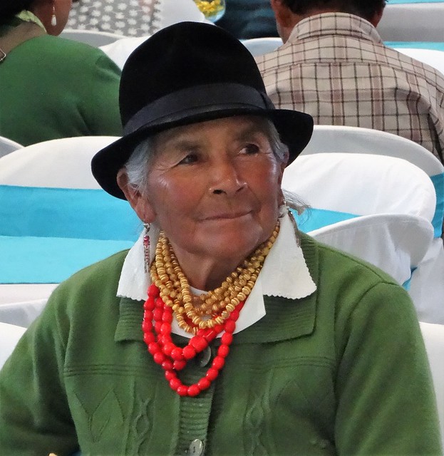
are either of Spanish, or indigenous, or both (mestizo) descent. There are several different cultures and all dress in their regional unique, brightly colored styles regardless of the activity. To us they looked too bulky and warm for the daily temperatures. The country is predominantly Catholic (as expected) and, therefore, there are many churches all elaborately decorated with Spanish architecture and gold, baroque style interiors.  

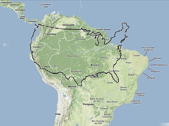
The Andes divides Ecuador and lies between the coastal (Pacific Ocean) and the Amazon Jungle. The Andes Mountains are the longest continental range in the world and extend 4300 miles (7000km) through 7 countries. This Highland region of Ecuador has an average elevation of over 15,000 feet (4.5km) with over 30 volcanoes, hot springs, cloud forests and the Andean Condor. The Highlands are populated with small isolated villages since travel is so difficult. Llamas are an often seen necessity as are the many markets to exchange goods (woven material, metal crafts, woodcarvings, dough figurines, and embroidery) and fresh food (fruits, vegetables, meat).

We found the Ecuadorians to be friendly, to be hard working, and to enjoy life. They have many more festivals and days of celebration than in the US, reminding us that our society values working hard more than enjoying 
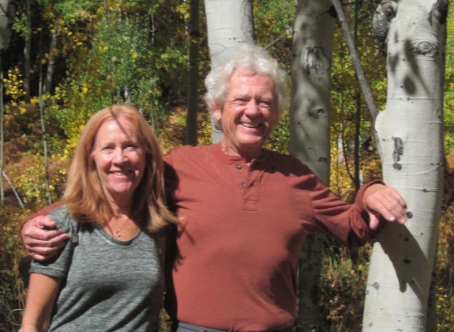
life. The Ecuadorians are dark complexioned and black haired.  We didn’t remember standing out so much since being in China. We were told that, if someone was looking for us, that they would look for the red and white haired couple!! It worked.

Our trip was loaded with delightful experiences which exceeded our expectations (except for seeing flamingos in the wild). We found the people pleasant, happy, and delighted to return a smile and a greeting. We hope that these photos convey these thoughts.


This concludes our 3 part blog on Ecuador, so until next posting “Happy Trails” and remember that we would love to hear from you. 
Andes

Sunday, December 25, 2016

Ecuador Amazon

The Amazon is the largest river on Earth extending over 4,345 miles (7000km.) The mouth of the river can be 120-250 miles (195-400 km) across in the wet season and large ships have no issues with travelling up river all across Brazil and into Iquitos Peru [2300 miles (3700 km) taking 23 days] from the Atlantic. The Amazon, with all its tributaries, makes up the Amazon Rainforest (also referred to as Amazonia or the Amazon Jungle) and is the largest on Earth. It covers 40% of South America and has a mind-boggling area almost the size of the US (see photo). The Amazon begins in the numerous rivers formed in the Andes in Ecuador and Peru.

One in ten known species in the world lives in the Amazon Rainforest as does one in five bird species. It is home to 427 mammals (e.g. jaguar, sloth, river dolphin), 1,300 birds (e.g. macaw, toucan ), 378 reptiles (e.g. anaconda and Jesus lizard) and more than 400 amphibians (e.g. glass frog and poison dart frog.). Amazonia is synonymous with diversity. In forests elsewhere on Earth, one’s view may include 2-3 of the same species of trees, yet the same view in Amazonia would yield a view of 30-40 different species.

With that in mind, we wanted to include a trip to Amazonia while we were in Ecuador. We flew to the town nearest the jungle (Coca) then boarded a boat onto the Napo River which flows into the Amazon River (along with a bazillion others.) There are next-to-zero roads and the river is the highway. Everything is transported via high-speed motorized canoes or barges. We wanted to go at least 60 miles (100km) into the jungle, which required a 2 ½ hour ride in a canoe powered by twin outboard engines going as fast as they seemingly could, then a short hike through the jungle to a manual canoe ride (paddled by 2 indigenous men), up a narrow creek into a lagoon, to get to our backcountry resort within the Kichwa Territory.

We hiked on the muddy trails through the jungle, climbed an observation tower to the jungle canopy, and took canoe trips (both day and night) up narrow creeks and into the lagoons in search of wildlife. The jungle did not fail to provide its splendor. We were treated to seeing 3 of the 5 species of monkeys, a sloth, reptiles, bats, insects, fish, and fauna up close and in their natural surroundings. Thankfully we did not encounter the kinds that can kill you, and there are many of those! We also visited the Kichwa in their homes, villages, and school. In the Rainforest live between 2-4 million indigenous people, 96% of whom are Kichwa. The Government gave the indigenous large parcels of land with the provision that it cannot be sold. They live quite isolated from modern society and live primarily on fish and yucca plants. No internet!

The weather certainly emphasized that we were in the rainforest. While it only truly rained on our trip into and out of the jungle, the high temperatures and even the higher humidity reminded us daily that we were definitely in a rainforest. It is a wild, remote, sparsely populated place and we are so glad we were able to experience it. We were sad to leave this part of our trip and also so glad that we added this adventure to our experiences. We hope that the photos show that. We have added descriptions to each photo to help describe them.

Our next posting with be a wrap up of our impressions of Ecuador, focusing on the Andes, the people, culture, and towns. Amazonia

Friday, December 16, 2016

Galapagos Islands

The Galapagos archipelago was created from volcanoes, much like Hawaii. It consists of 13 major islands and is located 600 miles from Ecuador to whom it belongs. The Galapagos Marine Resources Reserve is the world's 2nd largest, after the Great Barrier Reef. They have flora and fauna that is found nowhere else on the planet, and different species on each island. For that reason, they have strict regulations of what can come in or out of the islands and how many people can be in any one place at the same time. They even sprayed the overhead compartments in the airplane with an insecticide before landing. Charles Darwin came up with his theory of evolution by natural selection from studying the fauna on the islands. The famous “Darwin Finch” is now 13 different species. The tortoise has become the symbol of Galapagos and are the world’s largest tortoises. Drought is happening there too and sometimes the tortoises have to travel several miles inland in search of something green to eat. On another island, it was greener and food was more plentiful for them. Other daily sightings were of sea lions, colorful crabs, iguanas, marine turtles and tons of birds. Snorkeling produced countless sightings of colorful fish and coral, rays, eels, marine turtles, even a shark, and the younger sea lions found it fun to swim with us. After our Galapagos segment, we traveled to the Amazonian jungle, down Ecuador’s largest river, which will be our next blog. Galapagos

Sunday, October 16, 2016

Along the Nez Perce Trail

The Nez Perce (Nee-ME-Poo) are an Indian tribe in the Pacific Northwest. The name Nez Perce (pierced nose) was a name given to them by the French fur traders. Since they did not have pierced noses, the name probably came from some similar sounding word. Their first recorded encounter with the white man was with the Lewis and Clark expedition. The meeting was friendly, but as time went on,and as the US is historically known to do, the relationship went pear shaped. By 1877 they were at war with the US 7th Calvary after suffering abuses by the US.  Rather than be moved to Oklahoma, they took off on what today is known as the Nez Perce Trail. It is now a National Trail and is in western Oregon, Idaho, Yellowstone, and Western Montana. Since our summer travels crossed and followed this trail, we learned about these people and learned about their plight. Their story, although not unique, moved us so we decided to entitle this blog after this Trail.

Our summer travels took us from the Columbia River to the Clearwater, the Lolo, the Snake, the Clark Fork, and the Salmon Rivers. We traveled from the Blue Mountains in the west over the Lolo Pass through the Bitterroots, south to the Sawtooth Mountains, and east to the Rockies. The summer was cool and generally dry up there. We discovered remote campsites near these rivers with backdrops of the mountains on the horizons. Spring and summer wildflowers were our constant companions along with the sounds of the rivers.

We hope that you enjoy going along with us in our photos and we would love to hear from you.