The last time we were in the Pacific Northwest, we followed Lewis and Clark’s trail, followed the Columbia River from its headwaters in Canada to the mouth, saw the beginning of US 1, explored Olympic National Park, the Cascades, the San Juan Islands, toured the Willamette Valley, and explored the Pacific coastline in Washington and Oregon. This time we decided to travel along the Columbia River from British Columbia to Washington and then into the Idaho panhandle.
Since we had always heard about Hell’s Canyon and wondered what it looked like, we headed to the Snake River and Bitterroots of Idaho to find it. Hell’s Canyon is formed by the “Wild and Scenic” Snake River and is on the border between Idaho & Oregon. The canyon is largely inaccessible except by boat. The Snake River begins in Yellowstone and is the major tributary of the Columbia River. It is the largest US river that empties into the Pacific. We took a “jet boat” ride through the canyon for 32 miles, which is a safer way to go than rafting but not really as much fun and you don’t get as wet. We had never ridden upstream over the rapids before but this fast power boat flew up the class 3 and 4 rapids, and coming back down, was able to go back up and run the rapids over and over again. Hell’s Canyon is North America’s deepest river gorge, deeper than the Grand Canyon by over 2000 feet, which was a real surprise to us.
The canyon and areas surrounding it were mostly brown and parched. This was a clue of things to come. Our plan to explore scenic SW Idaho, including the Salmon River, was changed from all the smoke in the air as we learned of the wildfires there. The smell of smoke was prevalent and ashes were covering our truck and belongings. We changed our route and drove west into Oregon instead.
The Metolius River area in the Deschutes National Forest near Sisters, Oregon, is a fantastic river with many campsites riverside. Since there were also wildfires in Oregon, we encountered some smoke the first day, saw firefighting crews, and saw helicopters dipping buckets into the Metolius to fight the fires. Fortunately fires were put out, the presence of fire crews and smoke was short-lived, and we thoroughly enjoyed our serenity, the sound of the river, the clear views, and our isolated campsite directly on the river.
We had visited famous Crater Lake National Park in 2009 and had no intention of going there this time. However the proximity was difficult to resist another visit. Crater Lake used to be Mount Mazama at 12,000’, a volcano which erupted 7700 years ago – which is recent in geological terms. The mountain blew its top leaving the caldera which over time filled in with snow and rain to become Crater Lake. No streams run into (or out of) the lake, so there is no sediment introduced to cloud its pristine waters. This lake is the bluest of blue, as the water absorbs all the colors from the sun except blue. The lake is 6 x 4 ½ miles in size, and at the deepest point, is the deepest lake in the US - at 1943 feet depth.
Down into California and visible from 140 miles away is the landmark of Mt Shasta. It is not connected to any nearby mountain within the Cascade Mountains and therefore dominates the northern California landscape at 14,179 feet high. It is also a volcano, last erupting in 1786. Mount Shasta is geologically part of the Cascades and its origin is unique and not totally understood. It is in a major glacial valley yet has no signs associated with ice-age glaciers. As such there are legends and mysteries to its origin. Strange cloud formations appear over the peak. It is reportedly a “vortex” area where strong energy exists from within. This was first noted by Native Americans (Klamath) and many New Age psychics today “feel” the energy. This may be instrumental in drawing aliens to this area. Additional folklore is centered on a hidden city of advanced beings from the lost continent of Lemuria (the lost continent of the Pacific) and today remains a focus of New Age attention. New Age seekers come to this area to feel the energy by tuning in. Some believe that the energy may be enhanced by being naked or wearing aluminum foil hats.
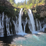
Naturally, there are many waterfalls and streams in the mountains. One fabulous and strangely unique one is located in MacArthur-Burney State Park in California. The 100 million gallons of water that flows daily over the 130 foot falls at this time of the year cannot be from the dry Burney Creek. Yet the water keeps flowing. The water comes from seepage inside the volcanic rock including the additional waterfalls undercutting the horizontal strata (i.e. not over the top). TR Roosevelt saw it and called it “a wonder” which it indeed was.
Lassen Volcanic National Park is the southernmost point in the Cascade Mountain range and is part of the Pacific “Ring of Fire” (as is Mt Shasta). This is one of the few areas in the world where all four types of volcano can be found (plug dome, shield, cinder cone, and composite.) Lassen is the largest plug dome volcano in the world! Who knew? Native Americans long ago knew that Lassen Peak was full of fire and water and thought that it would one day blow itself apart. The last eruption occurred in 1914-17. There are many hydrothermal features on Lassen. Steam temperatures can be as high as 322 degrees F. which is much cooler than lava (2000 deg F) or the core of the earth (12,000 deg F) which heats all of this. There are sulfur-smelling boiling pools, steam vents (fumaroles) and bubbling mudpots similar to Yellowstone NP within Lassen NP. Lassen has the highest amount of snowfall in California (600-1000 inches – yikes!) Therefore, there are also forests and waterfalls and views of the Cascade Range peaks. We took several multi-mile hikes everyday on trails that provided new sights and sounds. It is a wonder of nature to see the trees and greenery spring out of the volcanic rocks and from the wildfire devastated area, bringing this area back to life. It reminds us of a bumper sticker we saw- “Mother Nature always bats last”. She surely does. We will finish up by camping in Plumas and Tahoe National Forests and arrive in Sacramento. There we will prepare for another European adventure and a winter in Arizona. Until next time, Happy Trails!


